
I cannot believe that, in the past, someone actually tried to drain this marsh to use the area for farming. Lucky for us and for the wildlife, the land was donated to the Sycamore Land Trust. Bean Blossom Bottoms is now a protected marsh land home to many, including the rare Kirtland’s Snake.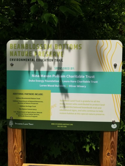 My son recommended we visit, so after a lovely lunch, we headed down.The Land Trust has completed repairing/replacing the boardwalk through the march. 2.5 miles of boardwalk!
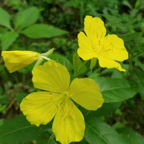
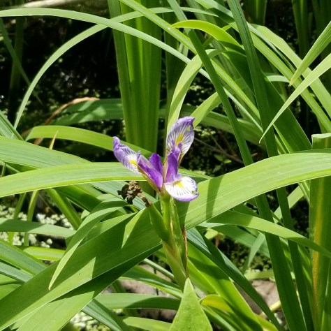
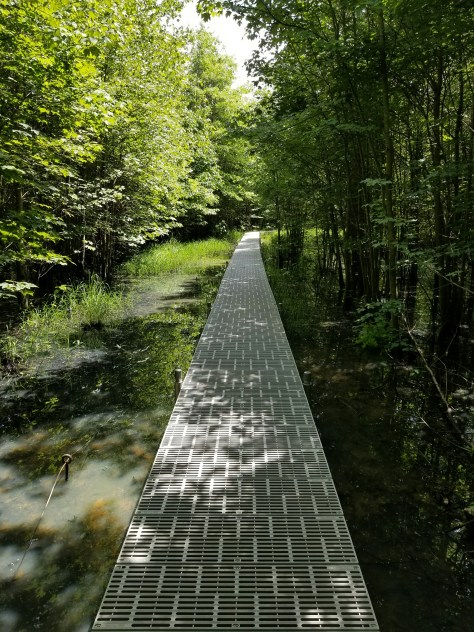 The number of water snakes we saw was impressive! We also saw tadpoles, wildflowers, and a baby bunny.
 I am sure crawdads call this place home by the looks of these mud towers. Or, do you think it could be something else?
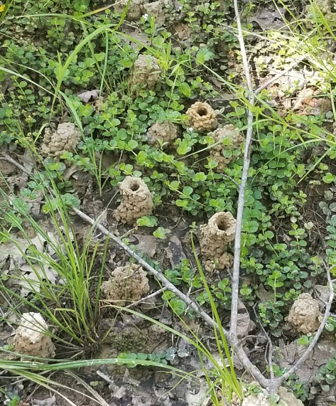 If you are in the Bloomington, Indiana area, then I recommend a visit. A marshy adventure…plus, you have to drive gravel roads to get here…a delight! Hike on!
Tag Archives: hiking in Indiana
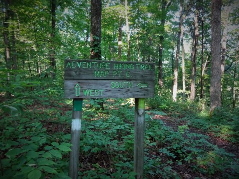
First Solo Backpack – Adventure Hiking Trial, oops, I mean Trail!
The Adventure Hiking Trail provided me with some unique challenges during my first solo backpack this weekend. I couldn’t anticipate all of what was in front of me, but I did research the trail as extensively as possible. It is a 22 mile loop around O’Bannon Woods State Park. A big shout to Ron White of the Ohio Valley Backpackers for the heads up on the trail head parking, recommendations for water caches, and some other general stuff! The Hoosier Hiker Council website was a great resource as well with links to a few good maps of the trail.
I had never hiked a trail where I had to cache water and was a little nervous that my cache would disappear before I got to it! Didn’t happen, my water was waiting for me!
This trail is in southern Indiana, which has a Karst topography. This topography includes highly soluble rocks such as limestone. There are many underground drainage opportunities, in addition to caves and sinkholes (of which I saw several). The water just doesn’t hang around on top, so all the creek beds are dry. Oh you might find a small pool here and there, but not nearly enough to keep one hydrated. Thus the water cache.

Limestone creek bed

Limestone creek bed
Friday night I checked into the Forest Office, then stashed water at two trail crossings, the crossing on Cold Friday Road and the one on Old Forest Road. Driving down Cold Friday Road was an adventure unto itself! Gravel, rutted in spots, and with one place where the road fords the creek (must happen only in a big storm because it was just a low bridge when I went over). As I placed my gallon of water, with my name and date of pickup labeled clearly, a rumble of thunder sent a chill up my spine. Okay, good enough, behind a tree…now for cache number two! Old Forest Road was a regular paved road. What a relief! I pulled off the road, thunder and clouds rolling, threw my gallon up in the woods and ran for it! I swear, I love and I hate thunderstorms and it all depends on where I am when they hit.
Anyway, water cached successfully so I headed back to Corydon, Indiana where I had a room at the historic Kintner House Inn. No hiker trash hotel for me! The woman who owns place is super accommodating and I recommend it to anyone coming to this part of the country.

The Joe Zimmerman Room at the Kintner House Inn.
They made me a special early breakfast so I could get to the trail early. It was a decent day for the middle of summer, mid-80s, low humidity, and no storms! My car parked at the 462/Old Forest Road lot (space for maybe 3 creatively parked vehicles), I did a last minute check of gear, then headed in a counter-clockwise (west) direction headed for the Ohio River Shelter.
Test #1: Do you like spiders? Or rather do you like spider webs…in your face, in your hair, draping from your nose and your cheeks to your ears and your chin to your chest? I looked like a freaking drum major marching down the trail raising first one hiking pole and then the other in quick succession in order to catch as many of the webs as possible before they hit my face once again. Every once in a while, I’d get lulled in a false sense of security, then WHOP, right in the face, spider on my eyeglasses, ugh. After about the billionth spider web, I gave up. I just started to plow right through them, with my lips tightly pressed together. NOTE TO SELF: Buy a hat with a brim and put mosquito netting over it.

My hiking poles were used as weapons of mass destruction. Sorry to the Spider Subdivision.
Test #2: Do you like wet feet? My feet were wet from dew in about 30 minutes of starting my hike and they didn’t dry out all day.
Test #3 Do you like to bushwhack? Because if you don’t, then stay off the trails in southern Indiana in the summer. All those winter pictures of the Adventure Trail that I found online…yeah, totally get it now. In general, I backpack at an average pace of 2 mph. It took me 5 hours to go 5.5 miles!!! Holy moly! When I reached the Iron Bridge, I sat down to have lunch just shaking my head. Was the rest of the trail going to be like this? Bushwhacking takes a lot out of you! On the positive side, the trail is extremely well marked! After I would fight through another bunch of overgrown grasses, briars, and young tulip poplars I was immediately rewarded with a trail marking. The emotional gratification of that trail marking cannot be overstated here!
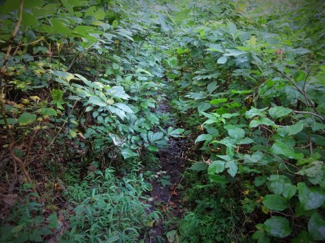
A lesser bushwhack that greeted me just after starting the trail.
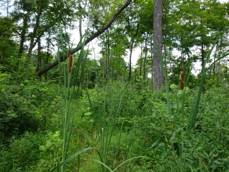
A more substantial bushwhack…do you see a trail…THAT’S BECAUSE THERE ISN’T ONE (or so you think)! This was on day 2 between Homestead and Indian Creek Shelters.
The trail improved after the Iron Bridge, so I was able to make faster forward progress, which put my head back in the right place. I followed a nice wide fire road from the Iron Bridge up to the Horseman’s campground. This was a planned water stop for me. While at the campground, I also took the opportunity to wash the spider webs out of my bandannas and clean my glasses which had so many webs crisscrossing them it was hard to see! Felt like a new woman!

The rest of the trail to the Ohio River Shelter was lovely. Well marked, well maintained. I reached my destination at 3:30pm. Shortly, afterwards, two guys came in from the other direction and we had a fun conversation about what we each had experienced thus far. They were out for a long day hike. In fact, I had just passed their water cache, which they had put in a tote bag, and chained to a tree…omg! I told them, “I was wondering about that bag and thought, wow, there must be something pretty special in that bag. I might have just found a use for my pocket knife…” They were good guys! Terrible, I can’t remember their names now…I’ll just call them the Evansville crew.

Beautiful Limestone

A BLUE fungi!!!

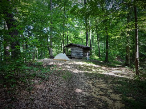
A quick break before climbing to the Ohio River Shelter

Ohio River Shelter…great view of river when leaves drop!
The Evansville crew gave me some good info on the trail ahead. There is more bushwhacking and the last two miles (their first two miles) was like my first 5.5. They also said, “There will be a place where you literally can’t see which way to go. Go straight ahead. It won’t look like it, but go straight ahead” I gave them my map and they pointed approximately where they thought that place was located. God, I felt like I was in Hunger Games.
The Ohio River Shelter is a popular spot. I was visited by a bunch of trail riders, a fellow backpacker from Indianapolis who I continued to leapfrog with all weekend, and a nice family who were taking their kids on their first campout. I tented, Adorable Family got the shelter, and I was totally okay with that! The shelters along the Adventure Trail are nice, but too closed in for my liking. They seem dark and dank. I preferred my tent.

Please don’t let that horse poo by my tent!!!
It was a beautiful first night out, with a bright moon shining down on me.
The next morning I was up and on the trail before anyone in the Adorable Family was stirring. It was going to be very hot today and I was hoping I could finish hiking at about 2 pm. First stop was Cold Friday Road to get my first water cache. Yay! There it was, waiting for me! I filled up my 3-liter bladder and 1.5 liter bottle, then drank what was left.

Yes! Let luck be with me today!!

While I was there, my Indianapolis buddy came by. This is when I found out he had not cached water. He had a filter and thought he would be able to get water on the trail….oh, buddy. He started up the next hill and I followed after smashing the now empty gallon jug and attaching to my pack. I caught up with him again, sitting on a slab of limestone in the middle of an almost dry creek. He had found a small pool at which to filter water. Thank goodness! I continued on up to the Homestead Shelter for a lunch break.

Homestead Shelter, great tent sites here! Also, a little history behind this site…original chimney!
Indianapolis buddy passed me while I was munching away. However, it wasn’t long before I caught up to him again. Honestly, I was kinda worried about him. He definitely was not drinking enough water, but I didn’t have any extra to offer him, but would have given him some if he had asked. The bushwhacking had come back full force today and it was freaking hot, like 95 degrees.
We hiked together then until we reached the Indian Creek Shelter, my stopping point. I know my limits…and heat is one of them. The bushwhacking was a trial for me and for Indianapolis buddy.
Ohhh…I forgot Test #4!
Test #4 Do you like climbing over blowdowns? If so, then you would love this trail! I lost count at 50.


It was nice to have to someone to share the bushwhacking and blow down hopping experiences with, for sure. I mean, here I am, in the middle of bushes that are taller than me, and I have to decide what to do when I don’t immediately see a blaze. It’s unnerving. I had to backtrack at one point to regroup and think it through. God, and it was so hot! I was so glad to stop hiking that day! Poor Indianapolis had to hike out…5 miles and less than a liter of water.
Very little tent area at Indian Creek Shelter, but I managed!
I took a look inside the shelter, immediately saw spiders. I sat down at the picnic table, immediately had a teeny little tick crawling up my leg. What is this place?????!!!!! Ummm…I think I’ll tent again. When I rolled up my tent the next morning, ants everywhere…I knocked off as many as I could…the rest have met with an unfortunate demise within the folds of Big Agnus.
Officially ready to end my first solo backpack, I headed down the trail immediately meeting my first blow down of the day. Despite the blow downs, this section from Indian Creek Shelter to Old Forest Road is definitely the prettiest section I hiked.

Gorgeous morning view!

Last Bushwhack!
There was more bushwhacking, and it took a while to get to the road, but it wasn’t as bad as day 1 or 2. I had my last water cache at the road. However, when I exited the woods the weather had taken a turn. Thunderstorm was on the way! The wind picked up and I left my cache and took off down the road to my car (1.5 miles away). Walking as fast as I could, I watched the clouds blacken and start swirling around. Thunderstorms in Indiana, oh god, yeah, great, a fitting end.
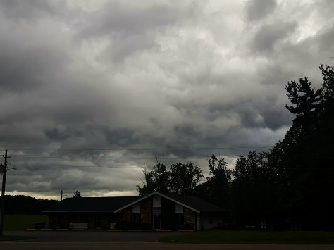
Angry clouds!!!
Test #5 Do you like hiking in Thunderstorms? Me either. After I passed a field of cows, I started looking for houses. The sky was seriously black now and really scary. I pulled in to a house and knocked on the door. Thank you, thank you, thank you to Carol K. for going out of her way and giving me a ride back to my car. Whew! That was a close one!
This trail tested me and I rose to the occasion, but I am paying an itchy price. Chiggers, poison ivy, ticks…and despite my using copious amounts of bug spray, my waistline is covered with red welts where I plucked off one little bugger (could have been a tick, could have been a chigger).
So while I dab on another layer of Calamine and pop another Benadryl…Hike On!
Browning Mountain and Basketball History (yes, Still Exploring Indiana!)
Down the road that goes to Elkinsville (or went to Elkinsville) is Browning Mountain. At 920 feet, I am not sure why it is called a mountain. I thought 1000 feet made a mountain…but I got that info from a movie in which cutie pie Hugh Grant played the lead … so you know, there is a slight possibility I am wrong! I am not bothered by that in the least. 🙂 Hugh Grant is “The Englishman Who Went Up a Hill and Down a Mountain” and very persuasive!
Over the years, I have heard some mysterious, almost magical, stories about the stones on top of Browning Mountain. These stones, which are quite large, are not native to the area and no one really knows how they came to be on top of Browning Mountain. Today was my day to climb the mountain!
Getting to the trail head was not a problem. We followed Elkinsville Road through Story, passed the Nebo Ridge Trailhead (stopped to get a map for future hike!), then went another mile or so until we saw the canoe rental place. We turned around there and backtracked about a 100 feet to find a spot to park on the side of the road next to the trail.

Headed up the Mountain
The first part of the trail is pretty steep, then you continue to climb along the ridge. We encountered several blow downs … seems to be a pretty regular occurrence on the ridges in Indiana.

It was a great day though, blue skies, gentle breezes, so the climb up was mostly delightful! We missed a right turn onto the trail that goes to the mysterious rocks somehow and kept walking for quite some time until we came to a fork in the trail. At this point, my sister, Rowena, was pretty sure we had come too far but wasn’t completely and totally sure, so we took the trail marked with two orange ribbons which headed to the left. When we started to go steeply downhill, Rowena decided indeed this was not the right way. So we back tracked to the fork and took the other branch…after another 15 minutes…nothing.

This is a trail marking???
Rowena had cell service so we looked on line for a website that might have a map or clues for which to look.

A geocache site stated that “There is a hidden intersection on the trail (look for the large, fallen tree that blocks the trail).” Okay, that is the STUPIDEST clue ever!!! There were at least FIVE THOUSAND large, fallen trees on the trail!!!
At least we knew two things now 1) the trail to the rocks was behind us and 2) the trail to the rocks was near a fallen tree. Alrighty-let’s go!
On our way back, we met a nice family from Cincinnati with two young girls. Together we found the trail without too much drama, Yay!

The rocks were pretty cool…but the whole spot is beautiful. Both my sister and I took some time to lay on the rocks and look up at the sky. Very nice!

BoobOnARock literally…
The adventure did not stop with Browning Mountain! On our way back home we stopped in at the Freetown History Museum, a one man operation in Freetown, Indiana. My sister volunteers at the Lawrence Co. Historical Museum so this was especially interesting for her! I wasn’t expecting anything, so of course, I end up finding something amazing!
Basketball history! But not your typical basketball history. The history of basketball in Freetown, Indiana. And…here’s the thing…the girls had a basketball team in Freetown BEFORE the boys! Check out the girls bball team from 1921 or 1922 in the photos below.

Mr. Fritz (to the right) unlocked the doors and gave us a personal tour!


This is so cool…and if Freetown had a girls team, then that means other towns would have had girls teams also, right? They had to play other teams! I want to know more…so if anyone out there knows anything about girls high school basketball teams in Indiana…let me know!!!
Keep exploring, learning and as always, Hike on!
Fabulous Sculpture Trail in Solsberry, Indiana
Continuing my tour of southern Indiana while I visit with family this week!
Today, my sister, Rowena, introduced me to the Sculpture Trail in Solsberry, Indiana. Along the way there, we found we were starving so we stopped in at the Yoho General Store. Rowena got a classic biscuits & gravy. I got the most vegetarian thing on the menu (without being potato salad) which was cheese sticks. It worked and we were soon off to find the Sculpture Trail.
Thank goodness Rowena was riding shotgun giving directions! There were a few twists and turns that would have probably resulted in me taking an all day drive without ever reaching any particular destination. There were also a few small signs, thoughtfully placed, to direct us to the Sculpture Trail so we were soon pulling off into a small parking lot.

Ahhh…another beautiful day in Indiana. We tromped into the woods, walking along a trail that skirted a ridge. I stopped to listen to fresh spring water cascading down a hill into a still pond and spring peepers chirping joyfully!
Continuing, I found a turtle standing stoically to my right as if his job was to watch the entrance to this magical place.

Then my eye caught something soaring on the ridge itself…a figure, arms thrown jubilantly skyward! Such accomplishment-how many times have I felt this after climbing to the top of a ridge?

In this same area, the woods took on a witchy feel. There were signs of a campfire in the middle of several sculptures.

Rising from the flames


An archway pulled me deeper into the forest. I quickly realized it was not an arch, but two separate pieces that arched towards each other. They looked like opposing thumbs! Rowena pointed out that the part that I thought looked like the nail bed on the tip of the thumb like structure was imprinted with a face. HOW CURIOUS!


We continued to wind our way around the ridge. The map provided at the trail head was a little out of date. No worries, I don’t think there is any way to get lost and it was a great deal of fun to just wander, look, and discover each piece of sculpture. It was like finding little treasures!


I could have definitely spent an entire afternoon just sitting in one area of this place studying a few pieces. A great place for meditation.
Then I saw something dancing in the woods ahead of me. Oh, wow. Wow.wow.
I fell in love with this piece. This was me.

This piece encompasses all that I feel as I waltz down a trail into the woods. Deeper and deeper until the branches of the trees above intertwine and the fog of the forest sweeps around my feet.
Hike on!
