Planning out Loud…Five months to go!

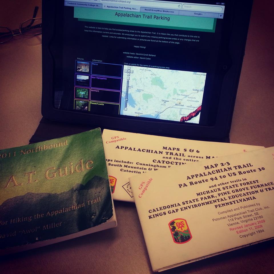
Officially planning for a backpack in May!  As I sort through my books…and I got a new one (insert happy squeaky voice)…I am sort of talking through the backpack.  The dogs are giving me the “oh god, again?” look and the cats are quite distracted as they have found the corner of my books are quite fun to rip apart.  Oh well, shoo cats, I have work to do. 🙂

So I think I will try to do 70 miles in 6 days…hahahahahaaaa….chortle, guffaw and all that nonsense. What am I thinking?  I prefer 8 mile days…But I am sticking to this plan for the moment.  I mean I have 5 whole months to prepare…

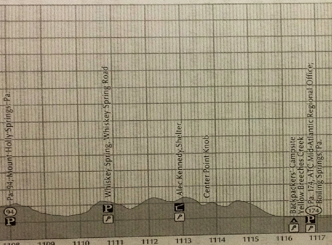
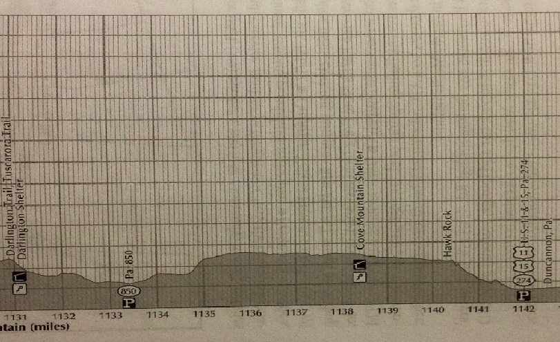
The elevation profiles are from my new book (yes, squeaky happy voice again 🙂  )  The ALDHA AT Thru-Hiker’s Companion.  Still love AWOL’s book, but the elevation profiles are a bit more detailed in the ALDHA book. Either book is a super resource to have when planning.   I take the official AT maps on the backpack.

Anyway, here’s the plan:

During the Trail Dame Camp Out: Section between PA94 Mt. Holly Springs and Pine Grove Furnace SP ~10.5 miles

Section A

The following week I will return to the area to backpack ~70 mile section.

Day 1: PA94 Mt Holly Springs, PA (1104.3) to Backpackers campsite (1112.5) 8.2 miles

Section 1

Day 2: Backpackers campsite to Darlington Shelter (1127.2)  14.7 miles No camping allowed in between!!

Section 2

Day 3: Darlington Shelter to Duncannon, PA.  (1138.5)  11.3 miles Stay in hotel.   Resupply as needed.

Section 3

Day 4: Duncannon, PA to Peters Mountain Shelter (1149.8) 11.3 miles

Section 4

Day 5: Peters Mountain Shelter to Yellow Springs Trail (Clearing with trail register, camping) (1163.3) 13.5 miles

Section 5

Day 6: Yellow Springs campsite to Swatara Gap, PA 72 Lickdale, PA (1174)  10.7 miles

Section 6So here’s to planning on a frigid winter day! Now I am going to sit back, have another cup of Peppermint tea and figure out how I am going to day hike all of Shenandoah National Park during 2014! Hike on! 😀

The Cure for Winter Doldrums

Cold is everywhere.  It was 1 degree Fahrenheit in Dallas, Texas today!  Overnight and into tomorrow, here on the eastern seaboard, we are under a wind chill warning…negative 15 degrees…ugh.  This is the time of year when it is easy for me to become a total slug.  I fall into the lull of winter.  I don’t want to work; I don’t want to hike.  Heck, I am in some kind of winter funk!

So today I made a conscious decision to do something that would energize me.  Little Caesar and I looked at our schedule a few days ago and decided that between the spring and summer semesters there were a few days in which I could go backpacking!!!  This is an unexpected and absolutely phenomenal turn of events!  I was pretty sure with everything we have going on right now that leaving Little Caesar with the dogs and cats in order to escape to the woods for a couple of days was out of the question.  Well, okay now, … I immediately pulled out my AT maps and books.  Where to hike? Where to hike…hmmm?  Pennsylvania! Yes, that would be good…close to home and yet I can get new AT miles.  🙂 🙂

Trail Planning!

Trail Planning!

In May I am spending a weekend with Trail Dames of Maryland.  We rented a PATC cabin in Pennsylvania and plan to stay two nights and hike our butts off! I will get a few new AT miles in just by being there.  But the following week, I plan on backpacking a little further north to Swatara Gap.  I contacted Google, the woman I hiked with in Georgia and Maryland, and she is game! Yes!

My winter doldrums are being held at bay for a while!  Planning for a spring backpack gives me a goal to work towards. It gives me a reason to get out and walk in town or on a trail regardless of the weather!  Although tomorrow when the wind chill is NEGATIVE 15 I will be inside planning! 😉

Knobstone Trail Oxley Memorial to Leota Trail Head

This gallery contains 4 photos.

Headed out this holiday season to visit family in my home state of Indiana.  While there I was hoping to get down and hike a bit of the Knobstone Trail.  I have heard this trail is used to train for the AT and as an AT section hiker I wanted to check it out to […]

AT – VA Blackburn AT Center to Snickers Gap

This gallery contains 2 photos.

What a delightful day with the Maryland Trail Dames!  This day was December 21, the winter solstice, and it was WARM!  Yes, a balmy 65 degrees! We met at the lot on Rt. 7 in Snickers Gap, then Dirigo shuttled us back to the Blackburn AT Center to begin our hike.  The first uphill from […]

The Gift – Camping, Hiking, and Listening to Canadian Radio

This gallery contains 5 photos.

My son, Logan, and I had some interesting experiences as he grew up…some good, some bad, some really awkward!  He withstood 18 years of living with me so I know he is made of fabric not easily torn nor easily wrinkled, although occasionally soiled.  This is why I wanted to give him a week in […]

C&O Canal: Point of Rocks to Catoctin Aqueduct…A Chilly Hike!

This gallery contains 16 photos.

My son came home from college for the Thanksgiving weekend on Amtrak.  We got to talking and he mentioned the train had gone over this really cool aqueduct he had never known about just before getting to Point of Rocks.  I said, “Oh, that’s the Catoctin Aqueduct!  They just finished refurbishing it…I keep meaning to […]

AT-WVA Blackburn AT Center to Keys Gap 11/23/13

This gallery contains 3 photos.

Out with the Trail Dames today!  I thought I was going to have to cancel this hike because my ankle has been causing me a little trouble, but the podiatrist gave the okay…sweet.  She taped up my ankle and sent me on my way!  My ankles just don’t work right is all…big time pronation.  Anyway, […]

11/16/13 Worthington Farm: Hiking the Battlefield on My Birthday :)

This gallery contains 4 photos.

What do I want for my birthday, more than anything else? A sunrise hike. Luckily, I was able to set out with Sidekick Pauli this morning to explore the trails on Worthington Farm, part of the Monocacy National Battlefield, in Frederick, Maryland.  Too bad Little Caesar had to work 😦 or she could have come […]

11/9/2013 A Frosty Start on Sugarloaf Mountain

Saturday morning I headed out at 8 AM for Sugarloaf Mountain.  I was leading a hike for Trail Dames (Maryland) at 9 AM and wanted to make sure I had enough time to get there to meet the Dames as they arrived.  Well, it was a good thing I left a little early as I was greeted with a full wind shield of frost on the car!  Now, my car is 10 years old and the heat…well, the heat is sporadic at best.  Actually, manic – depressive is probably the most apt description.  I either get hit with heat so hot I have to crack the windows, or air that feels like I have opened a freezer.  Anyway, the point is, defrosting the window was going to take a little time! 😉

Luckily, the coin flip was in my favor and soon I could see out the front window!  Off I went to Sugarloaf to meet the Dames.

It was going to be a beautiful day.  The sky was blue and as I passed a few farms along the way, I sighed in content at the frost covered corn fields.  Yes, this was autumn.  The crisp air, the sharp smell of wood smoke, and the rattle of bare branches on trees as the cold wind of winter tried to bully its way in.  I was really enjoying the morning drive to the mountain…of course, my heat was working which added to my contentment! 🙂

On the mountain I found 3 Dames already in attendance.  We waited for the rest of the group and after two rounds of introductions, we got moving…30 degrees this morning!  We followed the blue trail down the mountain.  Many of the leaves had fallen, which, in addition to the rocky path, made for slow going.  The leaves were a little slippery and a wrong step would have resulted in a none too pleasant fall on quite possibly a very pointy rock!

Once down the mountain we crossed Mt. Ephraim road and started the climb up to White Rocks.  Now, at this point, you may be wondering why I haven’t illustrated my post with some trail pictures.  Well, here’s the thing.  I did take my camera and it had a memory card and fully charged battery but when I took it out and tried to snap a photo of the Dames I got this message “the memory card is locked”.  Whaaaaaaaaaaaaaaat?  How does that even happen?  Anyway, I will insert one pic of the Dames at White Rocks which I stole from Boomerang.  (I made Boomerang an official co-leader on this hike, so it is only right that the leader should steal the co-leader’s pics when her own camera fails her 😉  )

Trail Dames at White Rocks

Trail Dames at White Rocks

We made it to White Rocks and had a moment with the beautiful view to the west of Sugarloaf.  I say a moment because it was really too cold and windy to stay up there for long!  I suggested we head to the big cairn in the woods to have a break.  The Dames were in agreement so we continued down the blue trail rolling up and over the hills.  The cairn is on a lesser summit and turned out to be a lovely spot for a break!  Great logs to sit on and the cairn provided a little shelter from the occasional gust of wind.

After our break, it was back to the ups and downs.  In the summer there are no views along this part of the trail, but in winter, wow!  We could see the surrounding ridges and countryside throughout most of the hike.  The sky was so blue and the sun shown through golden leaves that had yet to fall.  Just beautiful!

We finished our hike 4 hours after our chilly beginning, it was now a balmy 53 degrees!  Lovely day with a great bunch of women!  So glad we were able to share this time together!  The Maryland Trail Dames rock!!! 🙂 🙂 🙂

AT – VA A Great View on North Marshall Mountain in SNP

This gallery contains 2 photos.

Early last Thursday morning, someone hit my car and luckily left a note.  What started as an “oh crap” day quickly turned into a “oh yes, I get a nice rental car, and I don’t have to pay for it” day!  Right then and there, I decided that it was high time for a road […]